|
 Sheltowee Trace Trail Map Sheltowee Trace Trail Map
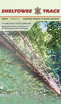
1:31,680 scale map that shows the ST from the northern terminus to Burnt Mill Bridge in the Big South Fork National River and Recreation Area. Is available in the Sheltowee Trace North and South map sets.
Map contains mile makers for the ST, connecting trails for section hiking, 50-ft elevaiton contours, and GPS lat/lon grid. Full-color maps.
Current outrageGIS maps
North map: $12
South map: $16
Available laminated
ThruHiking Journals
Over the years a few folks have hiked the entire ST, sometimes more than once! They logged their trips with journals and offer them here for your reading. Thanks to their great reporting, we have a sense of the trail conditions and hiker experiences that we can't get anywhere else, expect on trail.
Jonaharalia
I. B. Me
Sheltowee Wanderer
Chester's Thru-Hike
Want
to blog your ST journey? View
this post
|